.
.
.
Later this month, Garden Grove will vote on which plan it will choose for an ordinances creating its first-ever voting districts. If this article ends up being useful towards that end, it will have one of the weirdest origin stories of any districting map I know.
1. I Encourage You to Skip This Long and Self-Serving Introduction
I was very involved in the Anaheim mapping process, as I may have mentioned here, and belatedly threw myself into the Buena Park district process as well when it seemed that they not fully appreciating the task (which there included creating at least one Asian majority district.) I started on a Fullerton map, but ended up not following through, because I’m sort of at a detente with Fullerton right now. And as neither of my earlier maps were chosen, but both maps that were chosen were decent, I figured that Garden Grove did not need my interloping here.
Some anonymous poster here using the name “Anaheimster Insider,” either out of civic concern or a sick sense of humor, tried to goad me into drawing the map. I boldly resisted. Then I read a good Voice of OC article by Thy Vo that nicely spelled out the disagreements among the three maps in contention. I was intrigued, but still resisted.
Then Anaheimster Insider came back and activated the Bat Signal once again — the need was great and urgent. He or she wanted me to review the maps — even gave me the link (thus expending more effort than I usually see.) Mind you — I don’t know who this joker is. This person will only be able to take credit for prompting me to spent a pleasant afternoon with districting software — I do really, really love doing districting — at the risk of their losing their anonymity. (That itself will be punishment enough for goading me.)
So, having read about the disagreement, and been badgered by an anonymous commenter who seems sincerely interested in what I had to say, I took up the chisel. And I think that I may have a decent compromise plan.
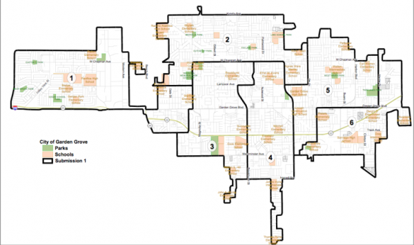
2. The Three Existing Proposed Maps, All of Which are Pretty Good
I’m not clear on whether there were only a few maps turned in by the public or whether only two of them (plus one attempted compromise map from the Consultant) were considered worth being finalists, but I’m following Thy Vo’s lead from her very important article on this subject (which I mention to reprise the link that you would have missed if you really did skip the intro) on describing only the following three maps:
2a: The Kim Nguyen Map
Kim Nguyen is the perfect demographic choice for mapping Garden Grove City Council Districts away from the city’s Latino-excluding history. (As I understand it from other sources, no Latino has ever been elected to the Garden Grove City Council — and its not for a lack of Latino residents or candidates.) Here’s how Thy described it, converted to bullet points:
- PRO: Supported by a coalition of Asians and Latinos. Creates two Asian-majority and two Latino-plurality districts. (Note: Thy describes the latter as “Latino majority.” She’s not in error, but: in mapping, we care more about the percentage of the “election pool” — roughly speaking, the citizens of voting age, or “CVAP” — than we do about the percentage of the raw population including non-adults and non-citizens. Despite the fact that in the raw population both Latinos and Asians are about 37% of the raw population, among the election pool you literally cannot make a contiguous Latino-majority CVAP district in Garden Grove.)
- CON: Slices up central Garden Grove vertically, which critics say divides neighborhoods — including dividing the Central Garden Grove Neighborhood Association among three districts.
2b: The Andrew Kanzler Map

Andrew Kanzler, a city Planning Commissioner, divides Central Garden Grove horizontally at Garden Grove Boulevard. Then it creates a vertical division into two northern districts above Garden Grove Boulevard, with each having a weak Asian plurality of about 40% but substantial . It leaves the southern portion, which includes most of Little Saigon, united and 61% majority Asian.
- PRO: Civic Garden Grove, a new community group including people who collaborated on the Kanzler map, say that its two northern districts are more competitive, befitting a “true democracy.” Sometime Orange Juice contributor Josh McIntosh spoke in favor of districts that are a mix of ethnicities rather than solid ethnic enclaves. (He also seemed to speak against traditional geographic divisions like “East” and “West” Garden Grove and Little Saigon. Desirable or not, that goes somewhat against the spirit of compact, contiguous districts.)
- CON: Vietnamese community leaders have argued that consolidating Little Saigon into one district constitutes undesirable “packing,” limiting the electoral influence of Vietnamese American residents. Thy quotes one saying that it would be “punishing the Vietnamese community for its [electoral] success.”
2c: The Consultant’s Proposed Compromise
Those are two starkly opposed positions — and neither of them are unreasonable. The city’s hired consultant, David Ely of Compass Demographics, proposed a plan that he hoped would include the best features of both maps:
Let’s quote from Thy directly before we get to the bullet points:
Ely’s map splits central Garden Grove into three districts stacked horizontally, with one district to the north of Lampson Ave split relatively evenly between racial and ethnic groups, and two districts to the south of Lampson with Asian majorities.
It also places Garden Grove Boulevard at the center of district 3, which is meant to capture most of the city’s Korean Business District into one electoral district. …
Ely said his map also splits the Neighborhood Association’s area of interest between two electoral districts. He has not recommended any individual map to the City Council.
“It’s my opinion that all of these maps would be perfectly acceptable or legal,” he told council members. “There’s different issues that could be raised about all of them, but I don’t think there’s anything that would be raised to the level of litigation.”
So the idea here is:
- PRO: Two Asian majority districts south of Lampson. A multi-ethnic competitive district north of Lampson. Unification of Korean Business District (which doesn’t seem to be a major issue in GG.) And it shouldn’t invite litigation.
- CON: I expect that both sides will take issue with Ely’s map, but the “Con” position presented here will come from me. Ely may not think that it invites litigation, but I have been in a protracted (by election law standards) courtroom fight against Mark Rosen, the election lawyer and former GG politico who sued the city last fall over their initial plan, and I’m pretty sure that if he’s not happy — something I can’t predict — then nobody’s going to be happy. After all, he wouldn’t necessarily have to win a lawsuit here, but simply bring a reasonable-sounding one that delays adoption of the maps for long enough that they can’t go into effect this November. (And as Neal Kelley would remind us, that means a final decision, beyond appeal, being in place by probably early July.)
So I’m going to offer my own proposal. It sprang from my noting that all three maps make similar choices when it comes to the portion of District 1 east of the umbilicus connecting West Garden Grove to Rest of Garden Grove. I think that I know why they did it — but here I think it’s the wrong choice. Making a different choice allows for what I think is a much better compromise.
3: My Compromise: Don’t Treat Stanton Like It’s a Volcano or a Lake.
The key to a compromise, in my opinion, involves first changing the shape of District 1: “West Garden Grove (plus part of western Central Garden Grove).” In other words, what happens after you head east on Garden Grove Blvd. between Hoover and Beach? (Ignore the highlighting for now.) The umbilicus we’re talking about is the pink-shaded little stretch north of the second to left exit number — exit 8 — on the Garden Grove Freeway.
Now when you’re districting, you generally think of making things as compact as possible. So, Kanzler’s and Ely’s maps head mostly southeast from there, covering all territory south and west of Garden Grove Boulevard and Magnolia. Nguyen turns left, rather than right, at Newland and Trask, heads to Magnolia and goes north to Lampson. You have to make it contiguous by law, but you make it compact because it helps people — including candidates — get from one part of the district to another.
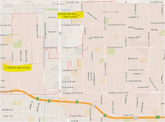
Now let’s go back to the highlighting. Let’s say that you’re at Pacifica High School and you have to carry a dozen vials of antitoxin to Rancho Alamitos High School — which, remember, is not in District 1 in any of the above maps.
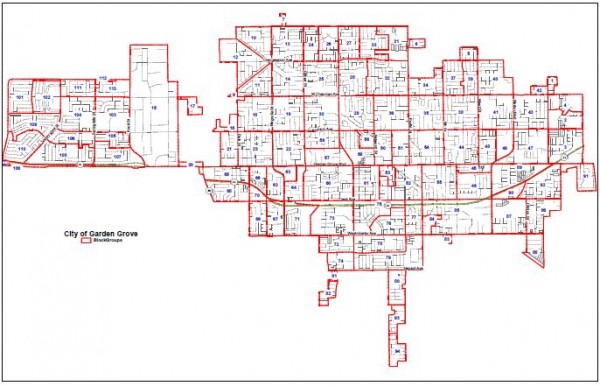
Your first tendency, if you’re doing maps — which means you’re looking at something like the district map at the top of this article that assigns numbers to “Census Block Groups” — might be to treat the area not within Garden Grove as if it were completely forboding, as if it was a lake containing volcanoes. In that event, you might choose a route like this:
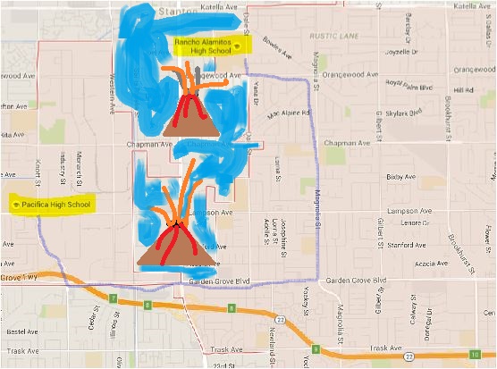
You drive down to the umbilicus — except that if I had filled in the water south of Garden Grove as well it would be a narrow isthmus — and you drive all the way to Magnolia before you turn left. (You can’t take Dale because of the lake inlet blocking it at Chapman. So you have to drive up to Orangewood, make a left, then turn right on Dale until you get there. That’s the kind of district that looking only at the map at the very top impels you to draw.
Yes, it’s contiguous — it HAS TO BE, by law! — but it’s actually not compact at all. You see, that’s not a lake containing volcanoes at all! Here, let me show you a better picture:
It’s Stanton. It’s just Stanton. And in fact, someone at the corner of, say, Western and Orangewood — further from the path through the Isthmus of Boulevard — is actually more a part of a community of interest, based on compactness, than someone at Pacifica Hugh, or someone who lives right at the isthmus itself.
So the most compact map — the one most respectful of voters in West Garden Grove — is going to be one includes the block groups on both narrow sides of South Stanton. Rancho Alamitos belongs with Pacifica, in other words. It need not look south towards Bolsa Grande or southeast towards Garden Grove High. Stanton is not a lake.
So, what you can do is turn left at Trask and Newland (as Nguyen does), cut to Dale and then up to Lampson, then east to Magnolia. Turn north all the way almost to Orangewood and take the Bowles diagonally northwest until it stops. What that does is take everything in the city west of Newland, and then above Lampson west of Magnolia except for the final half mile, into District 1. It gives whites a solid CVAP majority there of 54.3% — whites deserve to have a majority district too! It shifts districts north of Lampson ½ to ¾ of a mile to the east and opens up space to the west south of Lampson.
It turns out that this allows just the kind of competitive district that Kansler wants to the north — one with a narrow white plurality over Asians and about 20% Latinos. As it turns out, the district to its east turns out to be another similarly competitive district — this one with a narrow Latino plurality over Asians and about 30% white CVAP. The Asian areas in South Central GG are too big to be packed into one district — and instead we have two Asian CVAP majority districts. This configuration also offers what I think is the best possible Latino-plurality district in the city’s Southeast — especially given that unlike other maps I wasn’t able to break up block grounds 55 and 85 — with a 43.5% Latino CVAP.
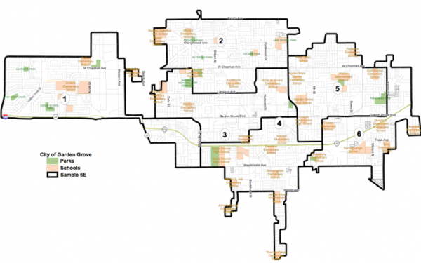
Let’s take a look. I’ve used color-coding to indicate the districts and well as drawing black lines around them and giving them names.

District 1 (in yellow) looks weird until you mentally fill in southern Stanton, at which point it can be recognized as quite compact. District 2 (in cyan) is compact except for Block Group 34, which can’t be helped. District 3 (in pink) is, except for its peninsula, extremely compact. District 4 (in purple) is long and narrow — I wish that I could exclude Block Group 35 and include Block Group 77, but doing so significantly screws up the numbers — but for the most party it is reasonably compact. District 5 (in magenta_ deviates a little from ideal form in curving around the top of District 6, but not too badly. District 6 is quite compact and incorporates much of the most Latino parts of the City.
The advantages by ethnicity pretty much follow the advantages in overall city CVAP. Asians, with 41.2% (see the top row of data in the legend) of the city’s CVAP, have two majority districts. Whites, with 31.2% of the City’s CVAP, have one majority and one plurality district. Latinos, with 24.6% of the city’s CVAP, have two plurality districts, the better of which offers a substantial advantage. Districts 2 and (especially) 5 are competitive among all three groups; District 6 is competitive among Latinos and Asians.
I don’t know what it was that Anaheimster Imposter was looking for — but that it what he or she will get! You’re welcome to leave your comments before I mail it to the Garden Grove City Clerk at about noon today (Monday April 4), which might leave to modifications, or at any time thereafter if you just want to kibitz.
God Bless you, Greg.
Geek-ery takes many forms, and yours is one of the more beautiful.
After all, he COULD be preparing for Wonder-Con.
Ive heard some complaints about the map by Kim Nguyen a staffer for lou correa as it makes the districts highly pro Vietnamese and minority latino thus making the latino population nullified in face of elections. This is coming from people involved in this process. Seeing as how latinos proportionately do not vote and viets turnout is consistently about 70% it would behoove correa to cater to the vietnamese population at he expense of his own latino population.
Paul, we seldom agree on anything…this ‘might’ be a first, but don’t let it go to your head.
:::Curtsey:::
http://www.ci.garden-grove.ca.us/internet/pdf/district_election/District-Proposal-Kim-Nguyen.pdf
thats the link to the map that lou correa staffer kim nguyen submitted. It looks to me as if latinos are being redistricted to be a substantial minority in representation by double p-percentages per her map. Greg Im not sure if I am correct or not can you reveiew the data spread sheet and confirm or deny that theory?
LLOU CORREA PRAISES GARDEN GROVE CITY COUNCIL FOR UNANIMOUSLY PASSING HISTORIC DISTRICT MAP
That’s great “LLOU” – now how about the same for Santa Ana?
http://www.loucorrea.com/#!LOU-CORREA-PRAISES-GARDEN-GROVE-CITY-COUNCIL-FOR-UNANIMOUSLY-PASSING-HISTORIC-DISTRICT-MAP/c5rk/5720fdbe0cf2dcaa531095da
Lou can’t make that happen. In fact, Lou doesn’t make much happen at all.
It’s up to you, complainer.
That is “Complainer in Chief” to you Birthday Boy.