Let’s say that we were constructing a new large city in Orange County from scratch. How would we want it to be governed? Don’t answer in the abstract; let’s take a real world example.
Remember this? It’s a South County section from the map of OC political geography I produced just before the last election. (I know that a bunch of you were reading this on Saturday morning, by the way.) Red shows the highest percentage of Republican share of two party registration, then orange, then yellow, and so on. You’ll notice that east of Mission Viejo, it’s very read. (This becomes important later on.)
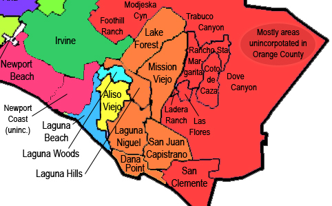
South County, defined for these purposes as including everything southeast of Newport and Irvine, had about 575,000 residents as of the 2010 census. I don’t want to cause too much trouble here, so while my mythical South County city, which I’ll call Nuevo Viejo, would sweep in unincorporated areas Las Flores, Coto de Caza, and Ladera Ranch, it would “grandfather out” long-established (that is, pre-incorporation of Irvine in 1971) San Clemente, San Juan Capistrano, Laguna Beach, and Dana Point, as well as old-in-a-different-sense Laguna Woods (which has a special status, sort of the “Vatican City” of South County.)
(Note that the populations and other vital information for each of Orange County’s 34 cities, plus the three unincorporated areas named above, as well as Nuevo Viejo, may be found in a big old chart at the end of this piece.)
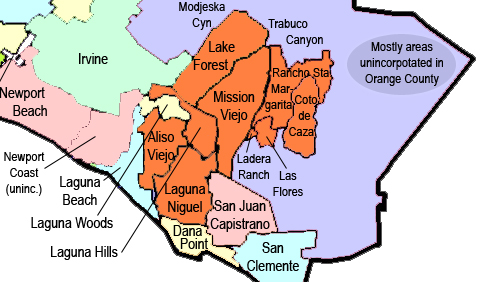
Cities and unincorporated areas chosen to become part of Nuevo Viejo are in orange. The others are spared.
This new city — which would include current cities Laguna Hills, Aliso Viejo, Rancho Santa Margarita, Laguna Niguel, Lake Forest, and Mission Viejo — would have a population of 403,385, making it the largest city in Orange County and the 8th largest city in California (slightly bigger than Oakland), knocking Anaheim out of the top 10. To give a better sense of its size, it would be about the size of Anaheim plus Yorba Linda — or nationally, somewhere between Atlanta and Cleveland, specifically fitting in between Raleigh and Miami. That’s a pretty significant city — one of the 45 largest in the U.S.
Let’s watch the transformation take place. First we take away the city and place names …
And then we dissolve the internal borders. Meet the (imaginary) new 8th largest city in California!
Now I’m not arguing that this is worth doing in real life (although it might well be!) given the low likelihood that its residents would want it; this is just a mental exercise in governance. But let’s say that they did want to do this — say, because they wanted an NFL team. Nuevo Viejo, composed of (let’s go biggest to smallest this time) Mission Viejo, Lake Forest, Laguna Niguel, Rancho Santa Margarita, Aliso Viejo, Ladera Heights, Laguna Hills, Coto de Caza, Las Flores, and maybe a few other small innocent victims nearby, would be a big and wealthy city, almost twice as populous (and, though a shade larger, twice as dense) as Irvine. In fact, it’s about 20,000 residents larger than Irvine plus the South County cities that I left out of the city. (If they want in, they can get in. Maybe.)
Now, the question regarding city governance becomes: should this newly created city have districts? If so, how many?
First, let’s ask how many people currently govern the areas that Nuevo Viejo would comprise. Mission Viejo has five city council members, not in districts, roughly one per 19,500 residents. Lake Forest also has five, roughly one per 15,500. Laguna Niguel — five, one per 12,500. RSM — five, one per 9,500. Aliso Viejo — five, one per 9,500. Laguna Hills — five, one per 6,000. The three unincorporated areas combined add just under 44,000 residents. Among these, the Ladera Ranch Civic Council has seven members — let’s generously call it one per 3,300 — Las Flores is, from what I can tell, essentially a part of Rancho Santa Margarita, so let’s give them one representative — and the Coto de Caza “CZ Master Association” website is closed to those without a password, making research difficult — so let’s presume that its 15,000 residents are governed by a single monarch. Toss in on more for County Supervisor Pat Bates and the territory of Nuevo Viejo currently has 40 representatives, or about one per each 10,000 representatives — roughly the same as do Aliso Viejo, RSM, and other OC cities such as Placentia and Cypress. That’s livable.
Now, put them all together in one city and what do we have? Let’s first consider a system where we have the same sort of “general law” style government that each of the six component cities have. That would be five people to govern that whole area. Theoretically, that’s one person for each 80,000 residents — an area about the size of Buena Park (or, South County-wise, a smidgen larger than Lake Forest.) If they’re elected at-large, though, that becomes pretty theoretical. (It takes a lot of money to win an at-large Council seat in Nuevo Viejo — and you don’t win one just by knocking on doors! Are you a big donor?)
So let’s say that this city, which would no doubt become a charter city, takes the path of having a Mayor elected at-large and four at-large Council members, as in Irvine. Well, actually, that doesn’t do much. These are still very expensive races.
Let’s say that, instead, Nuevo Viejo implements “Plan A”: an at-large Mayor plus four City Council districts. Now, it would have a Mayor answering to 404,000 voters and four Council members each answering to 101,000. So that might be: Council District 1A represents Rancho Santa Margarita, Ladera Ranch, Coto de Caza, and Las Flores (plus a little more from eastern Mission Viejo); Council District 2A represents almost all of Mission Viejo (plus a little more from northeast Laguna Niguel); Council District 3A represents Lake Forest and Laguna Hills (plus northeastern Alisa Viejo); and Council District 4A represents almost all of Aliso Viejo and Laguna Niguel. (Hey, look — Council District 1A is almost entirely that very red area we saw in the first map!)
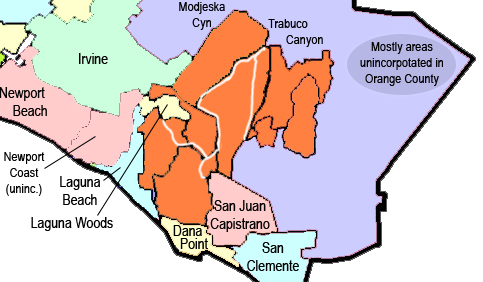
Nuevo Viejo with 4 districts (white lines). (I’m totally eyeballing this one without reference to population charts. Yes, it would look different if I used the right software.)
Are we happy with that? Let’s compare it to “Plan B”: a system with a Mayor plus six City Council districts, each now representing about 67,000 voters. How might those districts look? Let’s try this: Council District 1B includes just Rancho Santa Margarita, Coto de Caza, and Los Flores; Council District 2B includes the northern 67,000 voters of Mission Viejo; Council District 3B includes the southern 25,000 of Mission Viejo, Ladera Ranch, and 20,000 from eastern Laguna Niguel; Council District 4B includes all but the southern 10,000 voters from Lake Forest; Council District 5B includes those southern Foresters, all of Laguna Hills, and the northern 22,000 of Aliso Viejo; and Council District 6B incluses the western 42,000 of Laguna Niguel and the southern 25,000 of Aliso Viejo. That’s a little closer to the communities, though it does tend to split and combine them a bit.

Nuevo Viejo with 6 districts (white lines). Again, splits within cities are totally eyeballed, presuming uniform distribution of population, which there surely isn’t.
Can we do better? Now let’s try “Plan C”: a system with a Mayor plus eight City Council districts, each now representing slightly more than 50,000 voters. Now where do we stand? Council District 1C includes all of Rancho Santa Margarita and the closest half of Los Flores. Council District 2C includes Coto de Caza, the rest of Los Flores, Ladera Ranch, and about 10,000 out of eastern Mission Viejo. (More likely, southern RSM goes into District 2C and the District 1C takes the 10K from Mission Viejo — as I’ve depicted below. We’re just trying to get a sense of the size of communities represented in each district here.) Council District 3C is composed of the northernmost 50,ooo in remaining Mission Viejo, meaning that 33,000 remain. Council District 4C is the northern 50,000 of Lake Forest, with 27,000 remaining. Council District 5C combines the remainder of Lake Forest with 23,000 from western Laguna Hills. Council District 6C combines southern Mission Viejo, eastern Laguna Hills, and 10,000 from northeastern Laguna Niguel. Council District 7C is all of Aliso Viejo and a few thousand from an adjacent part of Laguna Niguel. Council District 8C is the rest — about 80% — of Laguna Niguel.
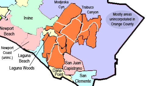
With eight districts, most of them come to resemble something that looks more like “communities of interest.” Again: the location of lines within cities has just been eyeballed and is not to be taken literally.
Let’s take stock here for a moment. Now, all of RSM could be in one district. The three unincorporated communities compose one district plus some close sections of Mission Viejo (or, again, these two districts likely trade territory — as I’ve depicted.) Most of Mission Viejo and most of Lake Forest are their own districts. A third of Lake Forest and most of Laguna Hills form a district. Aliso Viejo is basically its own district. All but 20% of Laguna Niguel is one district. And then we’re left with one district that contains minorities of three cities — all but the bottom quadrant of a circle centered on where the 73 meets the 5. That seems very respectful of existing community borders.
But what if we want to go crazy? TEN districts plus an at large Mayor, meaning just over 40,000 apiece? (1) Coto de Caza and Ladera Ranch — almost one district. (2) All but 8,000 in southern Rancho Santa Margarita — one district. (3) That 8,000 RSM, plus all of Las Flores, plus 26,000 out of Mission Viejo (leaving 67,000) — one district. (4) One district entirely composed of Mission Viejo, leaving 27,000. (5) One district out of northern Lake Forest. (6) Another district out of southern Lake Forest, plus a handful from the northwestern bulb of Laguna Hills. (7) The western 40,000 of Aliso Viejo, leaving 8,000. (8) The southern 40,000 of Laguna Niguel. What’s left? We have 27,000 left from Mission Viejo, 27,000 from Laguna Hills, 23,000 from Laguna Niguel and 8,000 from Aliso Viejo. Divide those that remainder up into a pair of districts however you want.
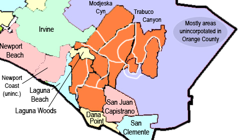
Ladera Ranch becomes Coto de Caza’s Kaliningrad. OK, no one out there got that reference, right? (I’m not doing 12 districts.)
Are we done? No, but it is time to shift gears.
If it’s not clear to everyone, thinking about districting in Nuevo Viejo is a way to sharpen our thinking about districting in Anaheim. Anaheim is a 15% smaller version of Nuevo Viejo, with a couple of major differences. First, rather than being divided up by bright city boundaries, it’s divided more informally into communities. But, a pre-existing community of 63,000 such as Laguna Niguel won’t be so different, in terms of how many people need how much representation, than some community of that size that we might find within Anaheim. It’s just that the different city names in South County seem to demand more respect than diffuse regional boundaries within a given city.
Of course, Anaheim has one other big difference from Nuevo Viejo as well. To understand this, let’s imagine a world in which a plague swept through Nuevo Viejo, sparing only Council District 1A from the four district example: RSM, Coto de Caza, Los Flores, Ladera Heights, and some adjacent slices of Mission Viejo.
Those eastern areas — which come to be referred to by the locals as “Nuevo Viejo Bueno” — are just fine after the plague. The rest of the city — dubbed “Nuevo Viejo Malo” — is relatively devastated. (By “devastated,” I mean that the median household income drops roughly in half, so that it resembles that of Costa Mesa. I don’t mean devastated devastated. The point is: not a lot of people in Nuevo Viejo Malo have a lot of money to run for office or to contribute to others’ campaigns.) Those outside of Nuevo Viejo Bueno also tend to vote less — partially, because the many of the remaining wealthy people who had been living there left and were replaced by a disaffected middle-class, working class, and poorer population that doesn’t monitor one another’s voting habits quite so aggressively.
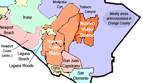
OJB objects to referring to the western majority of the city — now depicted in a lighter orange — as “malo” just because of a devastating plague, but in this fantasy that’s what the Register calls it, so we’re stuck with that label.
Let’s say that, in Nuevo Viejo’s at-large elections, a very large proportion of the city’s Council members come out of Rancho Santa Margarita and especially Coto de Caza. They have a lot more money to run campaigns (with lurid mailers warning the populace of the creeping influence of Irvine and Laguna Beach on city affairs.) And, on top of that, it turns out that a disproportionate amount of city services go to those regions within the big city. Is that a problem? How about if other parts of Nuevo Viejo become restless and even violent in response to police activities targeted at them — but not at the eastern end of the city?
You could imagine different solutions to this. In addition to electing its at-large Mayor, Nuevo Viejo could require one Council member apiece to come out of the four districts described above in “Plan A.” What they would likely find, though, is that with the whole city voting for each Council member, the winning candidates from outside of the eastern part of the city would be those who could best appeal to those voters from RSM and Coto de Caza — the ones who can pay for slick mailers.
What if we create four Council seats elected by district? That’s no problem for the wealthy areas in the east. They just divide up what used to be District 1A in half, combining the north half with areas of Mission Viejo and Lake Forest and the bottom half with parts of Laguna Niguel. With this new District 1A and 2A drawn advantageously, the greater propensity to vote among RSM and its unincorporated neighbors still allows control of these two Council districts — and thus, along with the at-large Mayor — the entire city.
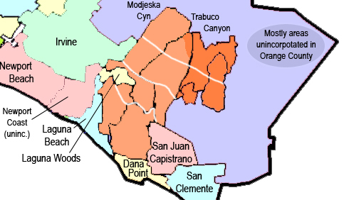
Because the quarter of Nuejo Viejo in bright orange “Bueno” votes at a greater rate than light orange “Malo,” it can easily win two of the four Council districts. Because the Mayor’s race in a city this size is so expensive, it can also win that seat — and a majority on the council — through the use of slick microtargeted mailers accusing the opposition of being in league with socialists in Irvine and Laguna Beach. (Nuevo Viejo politics is rough!) The residents of Buena don’t even have to compete in the two districts that are “del todo malo”; their representatives will consistently be outvoted 3-2 by the Council. (Make it eight districts instead of four, though, and this gets a whole lot harder for them.)
With more districts, though, this becomes harder to do. If the wealthy are located within RSM and Coto de Caza, you would probably hesitate to divide that area up four ways to provide for control of four out of eight districts. That becomes politically dangerous — an unexpected result becomes too easy. So, at that point, the previously powerful areas have to cut a good deal with the rest of the Nuevo Viejo for distribution of the burdens (such as police control) and benefits (such as city services) of government.
More districts means better representation — representation at a level where more individual citizens can dream of participating. This isn’t so much of a problem now, in the territory that could become Nuevo Viejo — with its 40 current representatives covering six cities and three unincorporated communities, allowing citizens to be closer to its government. After all, Nuevo Viejo is imaginary.
Anaheim, though, is real. Because it’s internally amorphous, though — composed just of “West,” “North,” “Central,” and maybe “South” along with the wealthier named communuties of Anaheim Hills to the East and the Colony carved out of the north (as well as industrial/commercial Anaheim Canyon-that-isn’t-a-canyon), it’s harder to see the inequities.
The example of Nuevo Viejo — where the three-quarters of the population in Lake Forest, most of Mission Viejo, Aliso Viejo, and Laguna Niguel can end up completely dominated by Rancho Santa Margarita and its small neighbors if the laws allow at-large voting, at-large voting in districted seats, or so few a number of districts as to make gerrymandering not only possible but almost inevitable — will, I hope, shed light on why Anaheim so badly needs reform.
Here’s the chart (mostly from Wikipedia) showing the relative populations of the existing cities of OC — plus that of Nuevo Viejo. The cities noted in black are outside of South County; those in green are South County cities that would remain intact, those cities crossed out in red and the unincorporated areas in pink would comprise Nuevo Viejo.
| Villa Park | City | Orange | 5,812 | 2.08 sq mi (5.4 km2) | January 11, 1962 |
|---|---|---|---|---|---|
| Las Flores | Uninc. | Orange | 5,971 | 2.28 sq mi (5.95 km2) | not applicable |
| Los Alamitos | City | Orange | 11,449 | 4.05 sq mi (10.5 km2) | March 1, 1960 |
| Coto de Caza | Uninc. | Orange | 14,866 | 7.97 sq mi (20.7 km2) | not applicable |
| La Palma | City | Orange | 15,568 | 1.81 sq mi (4.7 km2) | October 26, 1955 |
| Laguna Woods | City | Orange | 16,192 | 3.12 sq mi (8.1 km2) | March 24, 1999 |
| Ladera Ranch | Uninc. | Orange | 22,980 | 4.91 sq mi (12.7 km2) | not applicable |
| Laguna Beach | City | Orange | 22,723 | 8.85 sq mi (22.9 km2) | June 29, 1927 |
| Seal Beach | City | Orange | 24,168 | 11.29 sq mi (29.2 km2) | October 27, 1915 |
| Laguna Hills | Orange | 30,344 | 6.67 sq mi (17.3 km2) | December 20, 1991 | |
| Dana Point | City | Orange | 33,351 | 6.50 sq mi (16.8 km2) | March 22, 1911 |
| San Juan Capistrano | City | Orange | 34,593 | 14.12 sq mi (36.6 km2) | April 19, 1961 |
| Stanton | City | Orange | 38,186 | 3.15 sq mi (8.2 km2) | June 4, 1956 |
| Brea | City | Orange | 39,282 | 12.08 sq mi (31.3 km2) | February 23, 1917 |
| Cypress | City | Orange | 47,802 | 6.58 sq mi (17.0 km2) | July 24, 1956 |
| Aliso Viejo | Orange | 47,823 | 7.47 sq mi (19.3 km2) | July 1, 2001 | |
| Rancho Santa Margarita | Orange | 47,853 | 12.96 sq mi (33.6 km2) | January 1, 2000 | |
| Placentia | City | Orange | 50,533 | 6.57 sq mi (17.0 km2) | December 2, 1926 |
| Fountain Valley | City | Orange | 55,313 | 9.02 sq mi (23.4 km2) | June 13, 1957 |
| La Habra | City | Orange | 60,239 | 7.37 sq mi (19.1 km2) | January 20, 1925 |
| Laguna Niguel | Orange | 62,979 | 14.83 sq mi (38.4 km2) | December 1, 1989 | |
| San Clemente | City | Orange | 63,522 | 18.71 sq mi (48.5 km2) | February 28, 1928 |
| Yorba Linda | City | Orange | 64,234 | 19.48 sq mi (50.5 km2) | November 2, 1967 |
| Tustin | City | Orange | 75,540 | 11.08 sq mi (28.7 km2) | September 21, 1927 |
| Lake Forest | Orange | 77,264 | 17.82 sq mi (46.2 km2) | December 20, 1991 | |
| Buena Park | City | Orange | 80,530 | 10.52 sq mi (27.2 km2) | January 27, 1953 |
| Newport Beach | City | Orange | 85,186 | 23.80 sq mi (61.6 km2) | September 1, 1906 |
| Westminster | City | Orange | 89,701 | 10.05 sq mi (26.0 km2) | March 27, 1957 |
| Mission Viejo | Orange | 93,305 | 17.74 sq mi (45.9 km2) | March 31, 1988 | |
| Costa Mesa | City | Orange | 109,960 | 15.65 sq mi (40.5 km2) | June 29, 1953 |
| Orange | City | Orange | 134,616 | 24.80 sq mi (64.2 km2) | April 6, 1888 |
| Fullerton | City | Orange | 135,161 | 22.35 sq mi (57.9 km2) | February 15, 1904 |
| Garden Grove | City | Orange | 170,883 | 17.94 sq mi (46.5 km2) | June 18, 1956 |
| Huntington Beach | City | Orange | 189,992 | 26.75 sq mi (69.3 km2) | February 17, 1909 |
| Irvine | City | Orange | 212,375 | 66.11 sq mi (171.2 km2) | December 28, 1971 |
| Santa Ana | City | Orange | 324,528 | 27.27 sq mi (70.6 km2) | June 1, 1886 |
| Anaheim | City | Orange | 336,265 | 49.84 sq mi (129.1 km2) | March 18, 1876 |
| Nuevo Viejo | City | Orange | 403,385 | 67.44 sq mi (187.2 km2) | ? ?, 20?? |


You’ve got WAY too much time on your hands. Or you should start a political consulting outfit!
This was done over some period of time. If it helps shed light onto the Anaheim Districting issue, it’s volunteer time well-spent.
Thanks there at the end for what may be either of vote of confidence or a curse.
So it’s “New Old” … City, Town, Village? … what?
“Riche.”
It’s just a joke, skally, for a New city that would contain two “Viejos.” Thank you for translating it, though.
I determined to not slug through your epistle – what would be the significant differences between “Mission Viejo” and “New Viejo”?
Never mind then.
Meet Nuevo Viejo! A Case Study in Gibberish – or Gobblegook or Jabberwocky
Gibberish is a generic term in English for talking that sounds like speech, but carries no actual meaning. This meaning has also been extended to meaningless text or gobbledygook. The common theme in gibberish statements is a lack of literal sense, which can be described as a presence of nonsense. Gibberish should not be confused with literary nonsense such as that used in the poem “Jabberwocky” by Lewis Carroll.
I love it when I get this sort of reaction from you. It smells like napalm — and therefore like victory.
Single transferable vote would of course eliminate any worry about gerrymandering at all, but who listens to me?
http://kitchenmudge.wordpress.com/2012/08/08/are-we-as-smart-as-tasmanians/