OC’s Supervisorial districts are being redrawn, with applications due by 11:59 this Friday night. Here’s my take and an invitation for you to submit yours. (This post, by the way, was in effect commissioned by Ron Winship, who wanted to know what I had in mind for them. Thanks, Ron!)
If you want to try your hand at it, your instructions can be found here. (You’ll have to create an account.) The process is a little more difficult than the one used for Congressional and Legislative redistricting (about which I’ll write soon), and the software not quite as spiffy — for example, you can only see the underlying streets while dragging your map right or left — but it’s doable, especially if you cover broad swaths with the “rectangle tool” that assigns large numbers of “blocks” to a district at a time and lets you tinker with details later. I have other small gripes with it — finding “unassigned blocks” can take forever (which is why this wasn’t posted last weekend), and so far as I can tell you can’t assign whole cities by name, among others — but we’ll leave those for comments.
Here is the first “broad brush” map that I produced (not counting the magnificent one that I lost because you can’t save multiple drafts.) This one kept almost all cities — long and gigantic Anaheim being an exception — intact within single districts. I did not keep Supervisors’ current residency locations into account, because (1) I don’t think that that should “drive the bus” of redistricting and (2) I figure that Andrew Do will just move to wherever makes sense for him.
The inspiration for this map comes from a discussion we had here earlier this year about whether there was such a thing as “East Orange County.” The more I thought about it, the more I realized that there should be: because the cultural conservatism one finds in Yorba Linda, in Canyon Country, and in Southernmost Orange County seems to me to be of a piece — and stronger than almost anywhere else in OC.
I hadn’t considered, before trying it, whether one could draw a district all of the way from Yorba Linda to San Clemente (connected to one another mostly by the 55 and the 5, though it’s not like residents need to meet within their district.) It turns out that it’s really easy! (In fact, I discovered this when working on my Congressional district mapping, which I’ll publish later.) I think that “East OC” should be a standard for future mapping whenever possible. Yes, it means that some of “South OC” will be south of what I will call the “South” District, but we have to bear in mind that southernmost OC is also easternmost OC.)
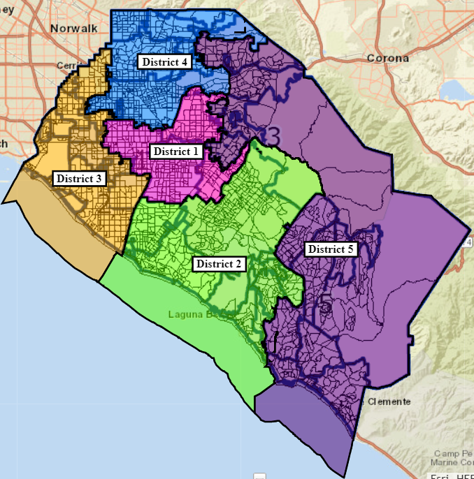
I numbered the maps using a counterclockwise spiral starting from the center to its south:
- Central (pink): Santa Ana, Orange, Tustin (except NE tip), Garden Grove
- South (green): Laguna Beach, Aliso Viejo, Laguna Hills, Laguna Woods, Newport Beach, Costa Mesa, Irvine
- West (gold): Huntington Beach, Fountain Valley, Seal Beach, Los Alamitos, Westminster, Stanton, Cypress, La Palma, Buena Park
- North (blue): Anaheim Flatlands, Fullerton, Placentia, Brea
- East (purple): Yorba Linda (all but westernmost), Anaheim Hills, East Orange (unincorporated), East Tustin (unincorporated and some incorporated), unincorporated East Canyons/Hills/CDUs, Lake Forest, Mission Viejo, Laguna Niguel, Dana Point, San Juan Capistrano, San Clemente
The only aspects of this that gave me any hesitation were (1) putting Laguna Hills into District 2 rather than District 5 — but it does abut Aliso Viejo and Laguna Woods (which seem politically similar to Irvine) and is a decent fit with Newport Beach; (2) Newport Beach/Costa Mesa to Buena Park via Seal Beach seems like a long stretch — but the Supes have done this sort of thing before; and (3) I didn’t like yanking off the southeastern limb of Tustin, but it’s a good fit with unincorporated Tustin and Anaheim Hills, which is also cut into two parts on what I call the “almost intact cities” map.” All of these seemed like reasonable concessions to get an East OC map.
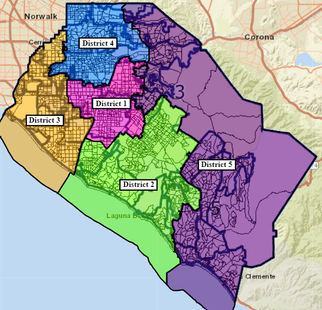
Keeping cities intact necessarily means allowing for some differences between districts, unless the cities magically fall into natural boundaries that match groupings that are substantively reasonable (or, ideally, compelling.) It doesn’t take all that much fiddling around to generate roughly equal numbers between districts, though it does create some mildly unpleasant looking modifications. (But also allowed me to get rid of some highly unpleasant aspects of existing city boundaries, such as that weird dangly part of eastern Buena Park and part of Yorba Linda at the Placentia border that is connected solely by a single road. Let me know if you want a close-up view of any border.) Making these adjustments leads to this result:
What about the demographic statistics? Let’s take a look. Each pair of demographics has a raw population number (which will be a whole number) followed by the percentage of district that represents.
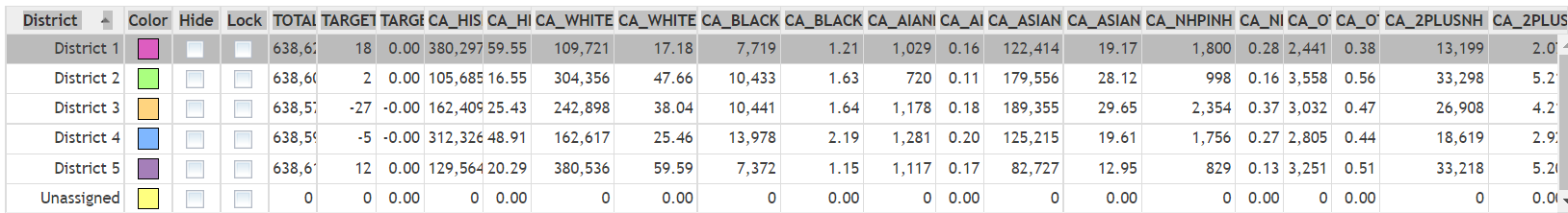
As you can see, there is one majority Latino district (Santa Ana’s, unsurprisingly) with almost 60%, and one near-majority district (the Northern one, with the Anaheim Plain and Fullerton.) The three others hover within 4.5 points of 21%. The white proportions are almost a mirror image, with one (the East) at almost 60% and one (the south, mostly coastal, district) at just under 48%. Whites are a plurality in the third (West) district with 38%, compared to 25.5% Latinos and 30% Asians — so demographically, if people vote that way, this one is highly competitive. Blacks don’t reach 2.2% in any district, unless some of them are hidden in the “2 or more races” category, and even that would not be that high. District 3, with Westminster and Eastern Garden Grove, would seem like the best bet for an Asian candidate.
I’ve already submitted this map, but your comments are welcome — especially as you come up with your own! Mail your screenshots to Vern to get them included here.
East OC District 5, I like it! Stick all the rightwingers and Trumpies into one district. That would be good for Democrats in general, and in the long haul. And really good for Greg Raths. Not so good for Poseidon-loving carpetbagger Joe Kerr but oh well…
Pro-gerrymandering, Vern? Really?
Haha, I didn’t make the map, and I’m sure that won’t be the map. But yeah, I almost used the word gerrymandering in my first comment.
I’m not sure political ideology counts as a “community of interest.”
As I say in the piece, Ryan, in terms of racial composition District 5 is almost a perfect counterpart to District 1, and District 2 is almost a perfect counterpart to District 4, while District 3 is balanced three ways. I did not try to calculate the partisan composition of the districts at all, though I suspect that District 5 is safely Republican, District 2 leans Republican and District 4 leans Democratic, and District slightly Republican.
I know how to gerrymander if I want to. This isn’t gerrymandering, and you should hesitate to throw out that sort of assertion so easily. I believe that there is a continuity of conservative political philosophy all through the hills to the bottom tip of OC — and that it is different from the more libertarian philosophy from Newport Beach and westward.
I’m happy to have a discussion along those “community of interest” lines. But if this was an attempt at gerrymandering, then I’m really, really bad at it. Would that Texans and Floridians were as bad.
Wasn’t a comment for you, Greg. Vern made a pro-packing comment.
That said, while D5 on your map is geographically continuous, the reality of needing to cross into a different district when leaving the northern part of the district to drive to the southern part doesn’t seem right. No other comment offered.
I think you could take the trip via the toll roads or Santiago Canyon Road.
It’s got to be 30 miles from Yorba Linda to San Clemente. Geographical compaction should always be a prime consideration.
Vern, Joe Kerr didn’t enter my mind, positively or negatively, in drawing this map. Frankly, this just slightly rearranges the group of people who will vote against him. Nor is it drawn to support or oppose Greg Raths, Lisa Bartlett, or anyone else in particular. I just think that the generally well-off people who seek the relative isolation of the hills (and to a lesser extent South County) are more similar than to others. Yes there are exceptions we could name — but there always will be.
The law says that you can’t gerrymander by race and ethnicity — and the numbers show that I haven’t. Political philosophy, where it doesn’t offend contiguity and compactness, seems like a *very* good principle to bring like people together for electoral purposes, especially within the sort of numbers exhibited here.
That’s not correct.
The CVRA says the opposite. When you can gerrymander to create a minority-majority, YOU MUST.
Not a whole lot of appreciation out there for that, let’s call it unique, requirement.
I know you weren’t thinking of Kerr vs Raths, it’s just the first thing that occurred to me when I saw that map.
Plus that it would make it a lot easier for a good Democrat to win in
District 3the neighboring districts.(You’ve also numbered them differently?)
*OK, Dr. D., was this map dedicated by Population first? District 5, of which we are a part seems a big too exaggerated unless the population is equal to the other four districts?
Meanwhile, Congratulations to the LA Dodgers for finally getting the “Ref Call” for once.
Hilarious that the Gants finally lost the Big One! Go Lasorda Burgers! Arte Moreno,,eat your heart out!